
The
Larapinta Trail and beyond. 2022
Despite our
years of bikepacking, and love for this form of travel, we have always been
hikers as well. What we love about hiking is the ability to get that bit more
remote and a lot higher, than we can on the bikes.
Hiking,
especially multi day unsupported hikes are much harder on the body than bikepacking
however. This had led us in more recent times to choose destinations that
allowed less weight on our backs, such as tea house trekking in the Himalaya,
where you really don’t need to carry any food or camping gear. (Although we
would still strongly recommend carrying a good quality sleeping bag).
Our love of
the mountains had led us to begin dreaming of some longer through hikes, but
getting into our late fifties, we didn’t know if our bodies were going to be
able to enjoy carrying that load as much as our adventurous minds thought we
could.
We needed a
test hike, challenging, but not too silly. It had to be long enough to find out
if our bodies were going to be able to settle into that magical rhythm of trail
happiness, before we committed to something too long. We’ve known from
bikepacking that if we start slowly and build up as our bodies adjust, then you
find that rhythm somewhere between day seven and ten, with day three or four
being the “what the fuck are we doing” days. Starting slow, in my opinion, also
reduces the risk of injury early on.
Of course,
there is also the issue of pack weight to be tackled. It’s possible to spend a
lot of money on lightening your load, so we decided that this was going to be
necessary if we were going to come out of this hike happy for more. Luckily, we
have already been through this process for bikepacking, so we already had some
gear that would cross over to hiking. Mostly we just needed lighter backpacks
and cooking gear.
So, the most
appropriate hike we could come up with was the Larapinta Trail. 223km long, we
were planning to take between 14-18 days. Luckily, we have a good friend who
had done the trail a few years earlier and her most important advice was to
slow it down as much as you can. This turned out to be great advice. One of the
mistakes that a lot of people make with the Larapinta is seeing that there are
twelve sections and thinking that this means twelve days. Especially for those
who go East to West, section one should really be taken over two days. The
profile looks almost flat, but as any experienced hiker knows, this is rarely
true. The trail doesn’t gain much altitude, but it is continuously up and down.
A lot of the commercial trekking companies do this and break a lot of people
before they even get to Standley Chasm.
Jacka Brother Brewery, Melrose
The
non-completion rate (I choose not to call it “failure rate”), is high. This is a very tough trail if underestimated.
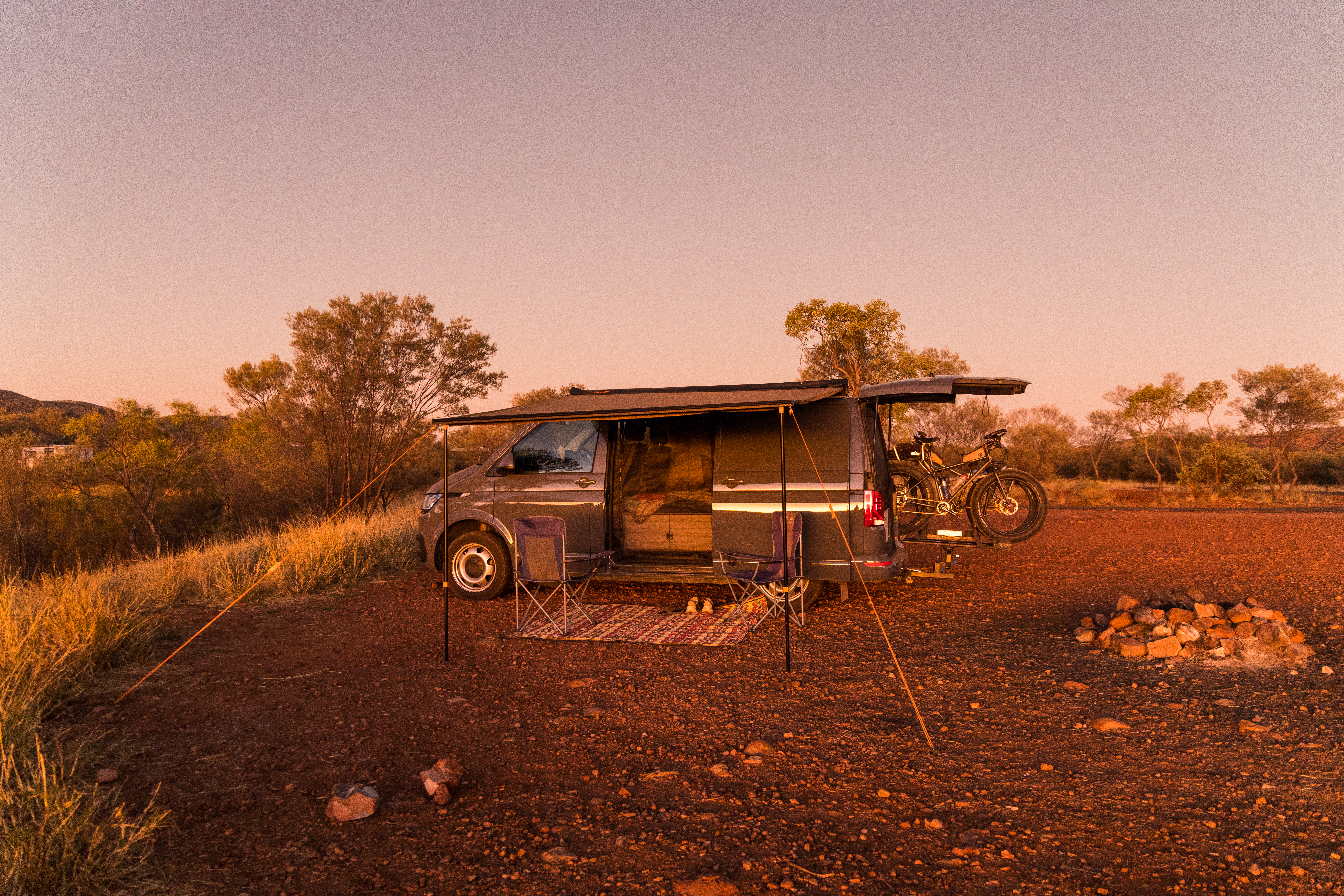
We drove up from Adelaide to Alice Springs in our van, wild camping along the way. We camped at the Heritage caravan park which fortunately offer vehicle storage for hikers at a reasonable daily charge. We notice that most of the other caravan parks offer a similar service.
 |
| Dinner on the Ghan Railway |
 |
| Waiting For Our Pickup, -3deg C |
 |
| First Night Wild Camp |
The next big
question was which direction. We decided on West to East, as this way we could
get dropped at the Western End, Redbank Gorge, and walk back to Alice Springs
at our own pace. This way we didn’t have to make a pre-booked pick-up date. So,
we booked a transfer and 3 food drops with local company LTTS and headed out of
Alice Springs on a very clear, very cold morning of July 27, 2022.
The day
before, we had packed our resupply boxes that would be dropped off at lockers
in Ormiston Gorge, Ellery Creek and Standley Chasm. This divided the trek into
4 sections, meaning we would be carrying about 4 days of food per section.
There are places to eat at Ormiston Gorge and Standley Chasm, taking out 2
meals.
 |
| In The Bus |
.
Transfer Day,
July 27, Redbank Gorge.
 |
| Redbank Gorge |
The gorge
had quite a bit of water in it, but was very smelly due to a fish kill caused
by a protozoa on the fish gills that occurs after a spell of very cold
temperatures. This had certainly been the case in the weeks leading up to our
trip, with Alice springs recording a record run of sub-zero morning
temperatures. When you add this to the fact that most of the gorges run
north-south which means that they get very little warming sunlight during the
day, the water temperature in the gorges was extremely cold.
 |
| Riverbed Camping, Note the food bag |
We settled
in for the night as the temperatures dropped quite suddenly as the sun
disappeared.
Day 1, July 28, Redbank Gorge to Hilltop lookout 15.69km,
500m vert
Being late July, the nights are long and daylight hours short. We love a good sleep in our tent, we’ve become expert at being comfortable and warm. It was hard to extract ourselves from our warm sleeping bags, it was very cold. But with some good prior planning, the stove, water and coffee were within range of not having to get fully out of bed. This has become our normal on cold mornings, breakfast while warm, then the lightning pack up and get on the move.
 |
| Kangaroo Grass Heaven |
 |
| Leaving Mount Sonder Behind |
 |
| Finally On The Trail |
It took a
little while to clear the shadow of Mount Sonder and finally get some sunshine.
It didn’t take long for the layers to start coming off from there. The first
10ks or so were a lovely meandering path through open woodland out to Rocky Bar
Gap. We were immediately blown away by the beauty and variety of the plant
life. We felt like we were hiking through a botanic garden.
We stopped
at Rocky bar gap for an early lunch and filled water bottles and a 2litre
bladder in order for us to be able to camp at Hilltop lookout, where there is
no water.
We crossed
through the gap to the North side of the range and started to climb. It was
only about 5km to camp, but the going got tough, especially with our full load
of water and food. We were really blown away by the standard of the track build
though. Properly formed switchbacks with rocks placed as bench seats on some
corners for a rest. This slope was very exposed to the afternoon sun, and there
was no shade whatsoever.
 |
| Curly Bark Wattle |
 |
| Hilltop Lookout Camp with Mt Sonder at Sunset |
We arrived
in camp and found a prime site looking right out at the magnificent Mount
Sonder and looked forward to the promised sunrise view in the morning.
Day 2, July 29.
Hilltop to Ormiston Creek. 10.39km, 81m vert
 |
| Mount Sonder at Sunrise |
Our main
reason for camping at Hillside was for the reported spectacular sunrise view of
Mt Sonder. It didn’t disappoint. We were up early to take it all in as we had
breakfast and slowly packed up. This sunrise was a real highlight and will be a
strong memory of the trail.

Walking on, the trail loosely followed a ridgeline before descending back down to the southern side of the range. The morning consisted of several creek crossings, and we ended up under a beautiful shady river red in the Finke riverbed for lunch. This spot is within sight of the Finke River shelter, but we decided to kick on a bit after lunch, toward Ormiston Gorge to find a place to camp. Once again, we filtered water here before carrying on.
 |
| Finke River Water Hole |
 |
| Ormiston Creek Wild Camp |
Day 3, July
30, Ormiston Creek to Ormiston Gorge. (Re-Supply) 8.47km 235m vert
Camping on nice soft sandy creek beds is really very nice, but don’t do it, ok? We had a great sleep and another very cold start. We were heading to our first resupply today, at Ormiston Gorge.

 |
| Mount Sonder Was Still With Us |
The 8ks or
so seemed quite challenging. Beautiful though, with several prime campsites,
especially the last creek crossing about 1k before Ormiston. Ormiston has a
good indigenous run café with toasted focaccias, cold drinks and quite good
coffee. We were feeling a little lazy and we could have a shower here as well,
so by the time we did all of that and re-supplied, we decided to stay the
night, which was a mistake. This was our first trail shelter that we camped at,
and it was busy, and noisy, and all in all, not very nice. Which is not a
reflection on Ormiston Gorge itself, which is awesome.
 |
| The Quality Of The Trail Building Blew Us Away |
Day 4, July
31, Ormiston Gorge to Mount Giles Lookout 14.43km, 600m vert
We decided to get an early start this morning and were walking not long after first light. Not much sleep was had, mainly due to the number of people in camp that night and all the crinkly mattresses.

We were soon
back out in our own private world again though, despite the heavy going for the
first few ks in the heavy sand of the Ormiston River bed. We did have trouble
with the coarse riverbed sand finding its way into our boots for the whole
trip. This section requires a two day water carry however, so we were quite
heavily loaded this morning. We had heard that there was water in waterfall
gorge that could be filtered the next morning if we were short. The trail
stayed on the Southern side of the range, rising and falling through the
landscape. We had great views out towards the South and every time we turned
around, we found Mount Sonder dominating the Western skyline.

Eventually the trail started quite seriously upwards towards the Mount Giles lookout. The climbing on this side of the range was much cooler however, and we really enjoyed it. Eventually we came out on a ridge that seemed to head East for a very long time, slowly rising. There are several great campsites up here and we eventually settled on a spot about 500 metres below the peak. This spot had a stunning 270-degree view and was quite exposed. So, despite the calm weather, we prepped the tent for high winds just in case. We had an awesome sunset and the only thing we shared the site with was a feral cat.
 |
| I Think It's That Way |
 |
| Camp Near Mount Giles Lookout |

Day 5,
August 1, Mount Giles Lookout to Serpentine Chalet Dam 15.82km, 407m v
We slept
really well until about 2am when the wind came up. The tent handled it well,
but it was noisy from then on. Cooking breakfast on the leeward side of the
tent was the order of the morning, wrapped up in our quilts to fend off the
cold.
 |
| Mount Giles Lookout Looking East |
 |
| Mountain Hakea |
The cold
Northerly kept us in our layers until we were over the summit and descending
towards Waterfall Gorge. This was our first really steep descent of the hike
and tested our knees which seemed to be ok.
Once down in
the gorge, we had to rock hop a bit and then noticed that we were being
shadowed by a large male Dingo. He was just curious and kept his distance. When
we arrived at the water hole, we filtered a bit of ‘just in case’ water, and
then sat back and had second breakfast while watching the parade of Painted
Firetail Finches coming and going.
Hiking out
around the water hole you pass through a gorge that brings you out into a
valley with very easy walking on well made loamy trail. This goes on for quite
some time before heading south through the Inarlanga Pass. This pass was a
traditional link point for the local indigenous trading routes. This was our
first sighting of the prehistoric cycads that inhabit this gorge. We ditched
the backpacks and had lunch on an amazing cool slab of rock enjoying the
serenity. From here on, this was a very tough section requiring scrambling over
boulders the size of small trucks.
 |
| Dingo Keeping An Eye On Us |
 |
| Finches At Waterfall Gorge Pool |
By the time
we got out of Inarlanga pass we were pretty stuffed and couldn’t face the idea
of doing the side trip out to the ochre pits, we were going to have the
opportunity to visit them on our way back out to Mount Sonder in the van.
We did the
last few ks into the Serpentine Chalet Dam campsite and decided to stay put
there despite there being quite a few people camped. It was nice though, and we
chatted with some really nice fellow hikers.
 |
| Ancient Cycads In Inarlanga Pass |
 |
| The Giant Boulders Of Inarlanga Pass |
Day 6, August 2, Serp Chalet Dam to below Counts Point. 4.66km, 168m vert

We came
across this awesome spot about halfway up the climb, set up camp and chilled
out for the afternoon having only walked about 5ks. This was as good as any day
off and we totally enjoyed it. A few people walked past us, saying what a great
idea and they wished that they either a) Had thought of that first, or b) had
the time to be so lazy. We agreed.
Day 7, August 3, Counts Point to 2k east of Serpentine Gorge 15.01km, 443m vert
The other good thing about our campsite last night, was that we only had a short climb up to Counts Point in the morning, which got us there with good light for the view still. The air was hazy from the wind blown dust though. From Counts Point the trail follows the ridge again for a few ks before dropping back down the South side. We arrived at Serpentine Gorge shelter at lunch time, so we had a long lunch chatting with some hikers heading the other way.
 |
| Very Brave Mouse |
We decided to kick on a few ks and find a wild camp which proved quite difficult to find due to the heavy spinifex. A creek just beyond West Junction looked promising on the map but proved to be a very rocky and narrow bed. In the end we found a spot that wasn’t too bad, and just big enough for the tent. Then the mice arrived. WTF, we were nowhere near a shelter. But we did have fun photographing one climbing in and out of my boots.
Day 8,
August 4, East of Serp Gorge to Ellery South, (Re-Supply) 9.34km, 362m vert
We woke to
light rain this morning, so decided to wait half an hour to see if it cleared
by the time we had breakfast. Fortunately, it did stop, and we packed up our
wet tent and hit the trail. Luckily it was resupply day, and our packs were
fairly light anyway.
 |
| Trig Point |
 |
| Ellery South |
The profile
on the map to Ellery South shows it being quite flat, but nothing could be
further from the truth. There was nothing very high, but the trail was
constantly undulating and tough going. Great views were had from trig point
despite not being very high.
Wandering
into Ellery South we set up camp in the sandy riverbed and headed for the
resupply lock up. The official highlights were a tin of sliced peaches, salty
chips, fresh fruit and a ginger beer. The low lights, more Radix meals, yuk. A
few other hikers had arrived for their resupply too, and it was fun sitting in
the shelter comparing those special treats that we had packed.
I made the
mistake of going for a quick dip in the big water hole. It was nice and clear
and very cold with no sign of the dead fish problem. However, once in, the
water didn’t smell that good and then the wind changed, blowing the dead fish
back from the opposite side of the pool. The price? Having to smell like dead fish for a few days.
 |
| Ellery Creek Big Hole |
Day 9,
August 5, Ellery South to Rocky Gully 14.93km, 491m vert
With full bellies, and full back packs, we hit the trail early, following the trail on the south side of the range for the first five kilometres. Then the trail crossed through a gap to the North side and out onto an open flat plain. It looked like it could be a hot afternoon with no shade out on the plain, but the walking was good and fast.
 |
| Between The Ranges |
 |
| That Big King Brown |
Rocky Gully
campground is a dusty exposed area, with a nice little dry creek bed going
past. As that looked like we would get some afternoon shade, we decided to camp
in a nice spot in the creek bed.
No sooner
had we set up, than I heard a loud thump and a rustle in the grass nearby. It
took me a while to realise what I was looking at, but then it dawned. A huge
King Brown snake had struck and captured a large lizard, which at the time I
thought was a Perentie, but turned out to be a Ridge Tailed Monitor. A very
large lizard, probably about 60cm long.
We videoed
it dragging it’s catch back to its lair, which unfortunately was even closer to
our tent. We decided that we didn’t want to camp there anymore, so we picked up
the tent in one piece and moved up to the main camp ground. Safety in numbers
right?
Day 10,
August 6, Rocky Gully to Hugh Gorge 15.14km, 386m vert
 |
| Lunch With A Friend |

 |
| Camp Near Hugh Gorge Shelter |
Day 11,
August 7, Hugh Gorge to Fringe Lilly Creek 8.54km, 198m vert
 |
| Looks Very Cold |
 |
The first
few ks up the gorge are just rocky/sandy riverbed walking and today the creek
was intermittently flowing, just gently in places. When we arrived at that
water hole, we could see a solo guy sitting on the big rock at the far end of
the pool, trying to work out how to do this. This was an opportunity for all
three of us. I suggested to him that if I wade across and hand our packs up to
him, that I could then carry his pack back so that he and I could swim around
the large rock. I would give Mary a leg up onto the rock, and well, I could do
with washing the dead fish stink off me anyway.
So that’s
what we did, and everyone survived to tackle the next section.
We had a
wonderful second breakfast in a sunny spot in the gorge while I dried out and
warmed up.
The going was pretty tough, but we took it quite slow, as the scenery was just beautiful and eventually found a very beautiful camp spot in fringe lily creek. We explored the gorge and had another swim.
 |
| Camp At Fringe Lily |
 |
| We Loved The Spinifex Pigeons |
Day 12,
August 8, Fringe Lily Creek to Stuart’s Pass 14.32km, 552m vert

We decided
to kick on and camp in Stuart’s Pass to put us at the base of Brinkley Bluff
for an early morning climb. This was a fabulous camp site on a sandy bank by
the most beautiful waterhole that we had all to ourselves.
 |
| The Big Climb Up Razorback Ridge |
We could have stayed here two nights if we had enough food.

 |
| Favourite Campsite At Stuart's Pass |

Day 13,
August 9, Stuart’s Pass to Standley Chasm 14.82km, 812m vert
The climb up
to Brinkley Bluff was tough. By the time we got some elevation the wind was up
and strong. On the last few switchbacks, we felt like we could just about be
blown off our footing.
 |
| Black Footed Rock Wallaby |
Once on the
summit, we thoroughly enjoyed the windy walk across the ridge and then, it’s
gently down until you hit the rocky creek bed for the last few ks into Standley
Chasm. This had been a tough day and it was very cool to sit down in a real
café having coffee, cool drinks and a burger.
 |
| Standley Chasm |
Day 14,
August 10, Standley Chasm to Jay Creek 14.13km, 506m vert
I think in
hindsight that we would say that this day was one of the toughest on the trail.
Just getting out around Standley Chasm was a monumental task, with very steep
climbing once again. Maybe our legs were just a bit burnt still from the
Brinkley Bluff climb?
But as
always, with suffering comes the rewards. Long creek walks, descending
waterfalls that we were super glad that they weren’t flowing. Then later,
ascending waterfalls. We had decided not to do the alternative high route
today, as we felt that we had spent ample time at the high viewpoints.
It was a
very sandy slog into the Jay Creek campsite, which was a great spot down by the
creek, away from the smelliest toilet on the trail.
Day 15,
August 11, Jay Creek to 2k West of Simpson’s Gap 21.20km, 437m vert
The profile
today was pretty flat, so we decided that we would pick up water at Mulga camp
and then just see how close we would get to Simpson’s Gap. A great day of
walking, with a very rewarding side trip into a very pretty Bond Gap. Despite
there being some nice camp spots just outside the cultural area, we decided
that it was the wrong thing to do and continued on. Of course, then it became
really hard to find a spot. Eventually we did and had a very cold night just
beside the trail.
Day 16,
August 12, West of Simpson’s gap to Wallaby Gap 18.14km, 366m vert
We’re not
sure what the temperature was, but the tent was frozen this morning. We were
very warm inside of course, so it was just that issue of getting going with
layers on and packing away a wet tent.
We passed
through Simpsons at second breakfast time and continued toward Wallaby gap. There
was a bit of climbing on good gradients up to Hat Hill saddle which offered
great views across to the Heavitree range.
Wallaby gap
is a bit of an ordinary campsite, but it had all we needed, and we were quite
excited about finishing the trail tomorrow. We were feeling very fit.
Day 17,
August 13, Wallaby gap to Alice Springs 18.24km, 426m vert`
We got going
reasonably early and got up to the Euro ridge lookout not long after sun rise.
This spot offers a spectacular view over Alice Springs. The famous wedgetail
eagles didn’t show up for us this morning unfortunately.
Now, the end
of the trail is officially at the Alice Springs Telegraph Station, just under
14ks from Wallaby gap. But we felt that to be a bit of an anti-climax. There is
a really nice trail from the Telegraph Station along the Todd River into Alice
Springs central, and we felt that spiritually, this last four ks needed to be
done for us to feel that sense of completion.
We had a
cold drink and a toastie at the station before finishing off into town and we
are so glad that we did.
A beer and
hot chips at the first pub, and then it was back to our van at the caravan park
and a couple of days R&R before stage 2 of the trip.
Day 18,
August 19, Mount Sonder Climb, 15.44km, 1006m vert, Total Ks, 234.58, Total climbing
7976metres
Fast forward
a few days and we were camped in the car park at Redbank Gorge with the wind
howling at 4am. We decided to stay in bed and do the climb a bit later despite
being woken by a couple of tour groups going in to get started anyway.
We almost
didn’t take our puffy jackets with us, which would have resulted in not
summitting. Once we were up on the ridge, the wind was very strong and cold.
But the gradient was reasonably steady and definitely doable. We loved this
climb as we were feeling fit, light and rested, we overtook several of the
groups that had left much earlier.
 |
| Mount Sonder Summit |
Many of the
people who started up Sonder today turned back before the top. We are not sure
exactly why, but that would be so disappointing for them, it was a wonderful
view.
Unfortunately,
Mary’s knee niggle returned on the way down, but we just took it slowly and
arrived back at the van for lunch and a cold drink from the fridge. Oh, the
luxury.
Stage 2,
Ride Drive test trip.
We spent a
couple of days in Alice Springs enjoying the various food and drink
establishments of which there are plenty.
Of note:
· Page 27 Café
· Sporties Restaurant
· Alice Springs Brewing
Then we did
a big shop and resupplied the van.
This was
going to be a totally new idea for us, doing a ride/drive. The idea was that
one of us would ride while the other drove and then we would swap around.
Camping and catering in the ultimate luxuriousness of our little VW Transporter
4motion.
The route:
We planned to ride back out through the West Macdonnell Range so that we could
see them from a different angle and ultimately climb Mt Sonder. Then onto the
dirt again with the Meereenie Loop around to Kings Canyon, Then Uluru/Kata
Juta, and back home via a section of the Gunbarrell Highway and the Oodnadatta
Track. Keeping the route as dirty as possible.
August 15,
Alice Springs to Standley Chasm, 64.05km, 414m ascent
We decided
to pop into our favourite Café 27, for an early breakfast and then we would
ride from there. Larry was excited about winning the toss and electing to ride
first today, we decided that I would ride out to Simpsons Gap via a bike track
that goes off through the West Macs, leaving the highway at John Flynn’s Grave.
What a treat this was. I expected a rocky scrape through the spinifex, but this
was a flowing, double lane, fully paved cycling highway complete with picnic
tables and concrete causeways across the creek crossings. Larry loved it.
I met Mary at Simpsons Gap and we walked into the gorge and watched the black footed rock wallabies for a while. We then got the twenty questions from a World Expeditions bus load of glamping hikers. They were cool and as fate would have it, we would see them again a few times over the next week or so.

It was now
Priscilla’s turn, and she was virtually doing wheelies out of the car park as
Mary tried to steer her in the direction of Standley Chasm. How dare you lock
me up in the van for three weeks!!!
I must admit
that driving while Mary was riding felt a bit weird for me, but maybe this just
a new skill to be acquired.
We arrived
at Standley Chasm, where we had camped only a few nights before. This time we
were in the van though, and it felt a bit weird not being one of the cool
hikers.
We walked up
into the chasm in the late afternoon and really enjoyed that we weren’t heading
up that flight of steps with a full pack again.

We grilled
on a camp ground BBQ and settled in for a great night in the van.
August 16,
Standley Chasm to Serpentine Gorge, 60.4km, 363m ascent
We had a
relaxed café breakfast before riding out. Despite the road now being all
bitumen for a few days, the going was very enjoyable and the traffic was pretty
light.
Swapping
over half way, we found a cool spot to camp for the night with a great elevated
view, so we decided we would finish the ride and come back in the van to that
spot.
August 17,
Serp Gorge to Glen Helen Resort, 45.19km, 328m ascent
The half way
point today was the Ochre pits, so we checked that out and continued on for a
walk back in to the Inarlanga Pass to soak up the atmosphere there for a while.
After that we rode on to Glen Helen Resort and enjoyed a beer and evening meal
there. We camped in the very exposed camp ground which is otherwise not worth
mentioning.
August 18,
Glen Helen to Redbank Gorge, 24.65km, 211m ascent
We did walk into the gorge this morning which was pretty nice and the water freezing. We were only riding to Redbank Gorge Today, so we had plenty of time. See Mt Sonder notes above.


August 20,
Redbank Gorge to Wild Camp on Mereenie Loop 96.6km, 532m ascent
We had
camped out at the Woodland camp outside redbank Gorge which was really good.
Today we were upping the effort a bit on the bike.

Mary started
off today and the plan was to meet her at the lookout for the Gosse Bluff which
is a massive meteor crater. The view was spectacular in the cool of the
morning.
I had a nice descent to start my section and at the turnoff to the crater, I realised that our communication had let us down. We hadn’t discussed if we would go in or not. The track looked rough and I wasn’t sure if Mary would tackle it on her own, so I decided that the smart thing was to keep going on the road. We were out of phone range.
Well, Mary
understandably thought that I would have taken the turn off and headed into the
crater. So she went that way. Meanwhile, I’m setting a good pace on the flat
road and are starting to wonder if I should stop. Oh well, sooner or later she
would realise that I had kicked on and she would catch up with me. I found this
experience very unsettling and resolved that we would need to plan our stops a
bit better, when Mary finally caught up with me I was a little stresses and
relieved. I had been imagining her bogged on the access road and here’s me out
there with one water bottle.
Anyway, Mary
was so impressed with the crater that we drove back there to check it out
properly, which was awesome.
 |
| Gosse Bluff, Meteor Impact Crater |
Then we
drove back to where Mary picked me up and she began her ride. It wasn’t long
before we turned West onto the Mereenie loop road and the dirt fun began. The
landscape was initially very open and desert like but then turned into awesome
windy road between large escarpments. We only saw a couple of cars, but the
road was quite corrugated and dusty.
 |
| On To The Mereenie Loop |
When it was
time to camp, we found a nice little claypan spot on the side of the road and
settled in to an awesome quiet night.
August 21, Mereenie Loop continued to Kings Canyon 102.85km, 383m ascent
We were just
loving this landscape and thoroughly enjoyed breakfast from the van with nice
coffee before Mary decided it was her turn to ride first again today.
 |
| Epic Landscape |
At the 15k mark, Mary was still visibly shaking. Not one to normally get scared of animals, she loves dingos, but this had really put the wind up her. For the next few days she would be constantly looking over her shoulder.

 |
Despite the
corrugations, the riding and the scenery was awesome. Eventually we had to
climb up to Ginty’s lookout before an awesome switchback descent and then into
Watarrka National Park. We booked into the massive caravan park at Kings Canyon
and enjoyed a meal at the Tavern.
The next day
we explored the park, the Kings Canyon Walk and perhaps more special, The Kings
Creek Walk. We found this an awesome experience. Kings Canyon is spectacular
too, but Kings Creek has a very deep spiritual feel to it. Amazing.
August 23,
Main Road section to Curtin Springs, 52.74 km, 113m ascent
The next
morning we had a howling South Eaterly blowing which was going to make the
riding very challenging, so we decided to drive down to the turn off to Yulara
and then ride. Not much to report from the ride, but we did stay at the Curtin
Springs Station free campground and had an awesome meal there. This is a
special place and we decided that we would really like to know more about this
place on our way back.
August 24,
Curtin Springs to Yulara, 86.84km, 220m ascent
We had a
cool ride getting into Yulara, and nothing is as special as when you get those
first glimpses of Uluru.
 |
| Uluru |
There were
some reasonable tent sites available back in the main camp ground, so we went
back to the office and changed to a camping site and put the tent up. This was
a much better solution.
We spent the
next few days exploring Uluru and Kata Juta, we hiked, we rode around the base
of Uluru, we took photos and we sat and experienced some of the out of the way
places. This is a major tourist attraction site, but we did find that
sometimes, if we waited and walked, we could find our own space a bit. Despite
the hoards, it’s an experience worth having.
 |
| Kata Juta |
On our last
day here, we drove back out to Curtin Springs and stayed there rather than the
Yulara Circus. Wedid a tour of Curtin Springs Spinifex paper making factory
that was really cool.
August 28,
Lasseter/Mulga park Rd Junction to wild camp Gunbarrell Hwy, 141.14km, 355m
ascent
Off into the
unknown again. We are still discovering the capabilities of our little van and
have been nothing but impressed so far. We were expecting rough roads from here
on.
Larry was
first to ride this morning, and it was a fantastic bit of gravel all the way
down to the Gunbarrell Highway junction. We swapped over a couple of times
really enjoying our time on the bikes.
Once on the
Gunbarrell we were flying along with a good tail wind until later when we
slowed down a bit as we started crossing low sandy dune country. I think we
only saw three other cars the whole day.
Eventually
we called time and started looking for a camp site. We just used a recently
bulldozed swale on the side of the road and settled in for the night.
August 29,
Gunbarrel Hwy out to Stuart Hwy, 92.08km, 246m ascent
After a
great night’s sleep we were on the trail again. The riding was really nice with
plenty of scenery diversity to keep us interested. The road surface was
reasonable but not fast. The Gunbarrel Hwy is just on the North side of the
South Australian border, so on our right, we were looking out across the APY
lands, a permit only, indigenous area.
Once we hit
the Stuart Hwy we packed up and drove down to Marla, having a shower, a good
meal and washing our clothes before starting the Oodnadatta Track in the
morning.
August 30,
Marla to wild camp on Oodnadatta Track, 100.96km, 280m ascent
The
Oodnadatta Track is quite famous in bush traveller folk lore and one of those
bucket list 4wd roads.
It’s funny
how things turn out to be very different to what your mind envisaged beforehand.
The riding was great, but I was beginning to struggle with my breathing. I
think it was the dust, but I’m not really sure, perhaps oncoming flu/covid? Who
knows. But I loved the ride today and especially loved our campsite out on the
gibber plains. But the next morning, after 5-10ks of pedalling, I felt I had to
call it.
Mary was
keen to ride, so we decided to have Mary ride but then we would drive a bit
further, allowing me to take it easy. So we meandered home, thoroughly
impressed with how our van was handling the terrain and totally loving it. We
camped at William Creek, having a beer at the iconic pub. We had lunch at the
Pink Roadhouse at Oodnadatta. Finally. We camped in Parachilna Gorge after
having dinner at one of our favourites, the Blinman Hotel, Northern Terminus of
the Mawson Trail.
After that
we headed home after a very fulfilling trip, having loved every minute. The
jury is out on the idea of ride/drive, but I think we will explore this idea
further.